


Bored to wait for maps to display? Use All-In-One OfflineMaps! Once displayed, maps are stored and remain available, quickly, even with no network access.
• Want more than just roads on your maps? You will find what you need here;• Used to go to places with poor network coverage? Everything will stay available;• Used to go abroad? You won't be lost anymore;• Have a data allowance limit? It will reduce your usage.
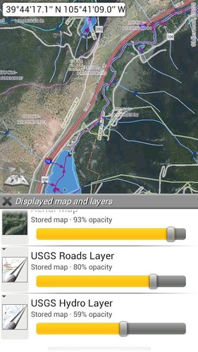
• MapsA lot of maps are available, including classical road maps, topographic maps, aerial (satellite) maps and various layers that can be added over any maps: OpenStreetMap (Roads, Topo), USGS National Map (Hi-res topo, Aerial imagery), Worldwide Sovietic topo maps, Google Maps, Bing Maps, Yahoo Maps, Yandex Maps, and various per-country topo maps (incl. Europe, UK, Spain, Italy).- All maps can be stacked in layers, with precise opacity control.- Select and store large areas in few clicks.- Stored space is clear and can be easily deleted.
• Display, store and retrieve unlimited landmarksYou can add various items on the map such as waypoints, icons, routes, areas and tracks.You can easily manage them using the powerful SD-Card Landmarks Explorer.
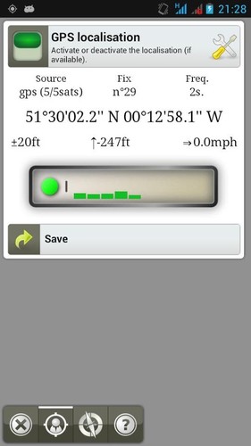
• On-map GPS Localization & OrientationYour real location and direction are clearly displayed on the map, which can be rotated to match your real orientation (depends on device capabilities).Easy turn off/on to save battery.
Fully compatible with metric, imperial and hybrid distance units, GPS Longitude/Latitude and grid coordinate formats (UTM, MGRS, USNG, OSGB, Irish Grid, Swiss Grid, Lambert Grids, DFCI Grid, QTH Maidenhead Locator System, ...).Ability to import hundreds of coordinate formats from www.spatialreference.org.
• Need more?If you are a real adventurer, try 'AlpineQuest GPS Hiking', the complete outdoor solution based on OfflineMaps, loaded with a powerful GPS Location Tracker.