

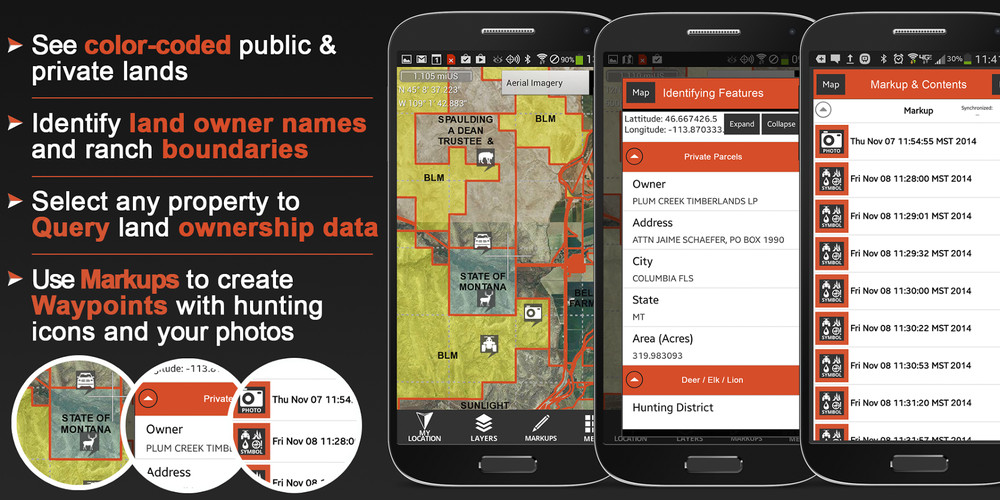


FREE FEATURES- Hunting Units layers, Game Management Units (GMU)/Hunting Units for general game species (for example in Wyoming you will see Antelope, Deer, and Elk units)- Basemaps of your choice to see Topo, Roads, Rivers, Lakes, etc - National Forest Roads and Motor Vehicle Use Map Roads and Trails- GPS functionality- Mark Waypoints with hunting and other icons to help you navigate back to your vehicle, camp, good lookouts, blinds, or just to mark places where you have seen game- Mark Waypoints using a photo you’ve taken to easily document the locations of scrapes and rubs, wallows, game sightings, food sources, bedding areas, etc. Bring this data back home to your iPad or computer to help you learn your hunting area much faster!PREMIUM MEMBERSHIP FEATURESPurchase a membership to your favorite state(s) to get the same great features of the free app but with the additional benefits of:- Selecting any Property to query Land Owner Name, Address, City, and State- Search by land owner name- Caching land ownership, other layers, and select Basemaps for use when you are out of cell phone coverage.
Map Layers:- Government and Public Lands- Land owner names with property boundaries*- GMUs or Hunting Units for as many different species and special hunt types as we can find available for that state (for example, in Wyoming you will get Antelope, Bighorn Sheep, Bison, Black Bear, Bobcat, Elk, Moose, Mountain Lion, Mule Deer, Mountain Goat, Turkey, White Tailed Deer, and Wolf Hunt Areas- Section Lines and Numbers- Topo, Roads, Rivers, Lakes, etc are all provided on various Basemaps that you can choose from
* Private land ownership information may not be available for all counties. Please see the plat coverage map on our website for a map of current coverage.
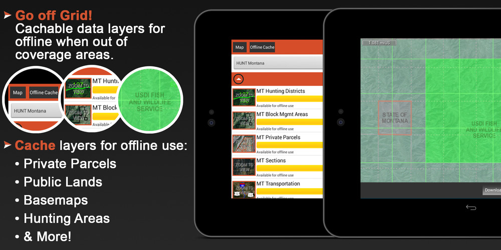
Cacheable Basemaps:- USGS Topo- Aerial Imagery- Topo (Open Cycle)- Open Street Map- USGS Hybrid (Topo + Imagery)- and more!
Other Basemaps:- World Topo (ESRI)- World Imagery (ESRI)- World Streets (ESRI)
}--}---> FREE TRIAL <---{---{You can try our full featured map Membership for 7 days (the app will automatically start a free for the state you are in when you install the app).
GPS FUNCTIONALITYThe HUNT app uses the GPS built into your phone to display your location on the map. Cellular network coverage is NOT needed to use this app and the GPS functionality. Proprietary tile caching technology allows you to cache basemaps and all other key map layers for use when you are away from cellular network coverage.
All 50 states are available!AlabamaAlaskaArkansasArizonaCaliforniaColoradoConnecticutDelewareFloridaGeorgiaHawaiiIowaIdahoIllinoisIndianaIowaKansasKentuckyLouisianaMaineMarylandMassachusettsMichiganMinnesotaMississippiMissouriMontanaNebraskaNevadaNew HampshireNew JerseyNew MexicoNew YorkNorth CarolinaNorth DakotaOhioOklahomaOregonPennsylvaniaRhode IslandSouth CarolinaSouth DakotaTennesseeTexasUtahVermontVirginiaWashingtonWest VirginiaWisconsinWyoming
UPDATESAs land ownership, GMUs, and other map data change we will update the map data on our servers. This new map data will automatically be loaded to your App without you having to do anything! As we make updates to the map data we will keep you posted by sending ‘Push Notifications’ to you within the App. Make sure you ALLOW PUSH NOTIFICATIONS within the App if you wish to receive these messages.