


FAQ: (updated for Wearable and Backup/Restore support!) http://goo.gl/VAMzij
Metam is everything you've wanted for your global aviation weather needs and more:
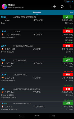
1. At its core, you create lists of airports important to you, either individual, or along a flight path. Display their METARs in parsed or raw format, access color highlighted TAFs quickly, cryptic Snowtams are decoded for you into plain language, access NOTAMs and forecasts efficiently.
2. Metam offers a side menu full of aviation weather charts and imagery. Current observations, forecasts, flight level winds and temperatures, satellite, radar, operations and more.
3. You can now overlay global METAR, SIGMET, G-AIRMET and CWA data onto maps (Android 3.0+ only). Also radar/precipitation or IR satellite. Also, you can now enter custom ceiling and visibility minimums to quickly see airports that meet your personal or company visibility/ceiling requirements. Tap on any airport or overlay to get the full METAR/TAF/TEXT for that airport/overlay.
4. Need quick access to raw METARs and TAFs on your Wearable? As of version 4, this is supported too. Use "OK Google, start Aviation Weather"!
Metam is and will remain 100% ad free and uses the minimum of permissions to get you what you need. In-app purchase is only included to offer the user a method to donate, if they choose. Using Holo UI, Metam offers a comfortable, familiar experience compatible on devices back to Android 2.3 (except Maps, which requires 3.0 and up).
Weather charts included with Metam:UNITED STATES (most ADDS products): * Advisories: SIGMET and Oceanic SIGMET* Observations: Composite map, PIREP map, METAR map, Satellite, Radar* Forecasts: Surface Prognostic Charts, Upper Air charts (wind & temps), AIRMET charts, Graphical Turbulence Guidance
ALASKA AVIATION UNIT: * Hourly observations, graphical forecasts, SigWX charts
GLOBAL: * Observations: Static and animated satellite, regional satellite* Forecasts:European Surface, Europe SigWX/Upper Air, Canada/North Atlantic, Upper Air Wind/Temp, 24 hour SigWX
OPS: * Products: US Airport& Airspace Status, Daily North Atlantic Tracks Graphics
Why use Metam?* Airport input flexibility: Individual airport listings (NZCH WSSS EGLL) or flight path listing (KJFK-KSFO) Supports IATA: Use IATA code (LHR, JFK) if you prefer
* Flight path input lists all airports along the great circle route within 10 NM of the flight path, supports multiple airport waypoints (airports only, no navaids)* Four different weather list formats: Formatted weather, METAR only, TAF only or METAR & TAF listings* Long-press on an airport for: Six hour METAR history, sunset/rise times, show nearby airports and more* Multiple cloud layer display: Metam shows up to three reported cloud layers* NOTAM: Cached for offline use, parsed effective times (Android 2.3 and up only)* Global airport database: Look up ICAO by airport name* Snowtam decoder: Snowtam codes in plain language* Widgets: Single airport with raw METAR or parsed.* METAR & TAF Highlighting:Color codes raw METAR and TAF text * Displayed unit choices: User chooses* Ad Free: Metam will never include ads
*Permissions*Precise location: nearby airportsRead/modify/delete USB storage: Google Maps requiredNetwork access/view network connections: download dataRead Google service: Google Maps requiredGoogle Play billing: In-app donation (optional)
Metam User group:http://goo.gl/OgXMJ